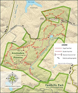
The Arastradero Open Space Preserve Map shows the Palo Alto park with shaded relief, trails, trail distances, parking, and gates.
Map Version 24 • Download PDF (1.9MB)
![]()
This map is a copyrighted work and is licensed to you for your personal use only. You may not modify or re-distribute it. Feel free to post links to this page. If you have suggestions for improvements, please send them in.
The map is designed to be printed in color on letter size paper. Of course if you can print it larger, it will be more pleasant to read.
The map is updated from time to time, so revisit this page to get the latest version.